Blog from the field
Join Arctic Safety student Fabienne Mannherz for an excursion to Sarkofagen.
From the top of Sarkofagen, overlooking Longyearbyen. Photo: Fabienne Mannherz
Text and photo: Fabienne Mannherz
On Friday, 26th August, the AS-302 course of the Arctic Safety Centre went on an excursion hike to look into the natural hazards and safety barrier elements discussed during foregone lectures. The tour looked like this: We started from Nybyen, hiked up the side of the glacier “Larsbreen”, hiked onto the plateau of “Sarkofagen”, descended on the other side and then hiked back on Longyearbreen glacier.
If you are interested in the topography of Svalbard, here is an excellent website tool which all locals use for tour planning. The best Scandinavian weather app is called “yr” (or yr.com). You can also use windy.com for some more detailed information on wind conditions. However, to go on trips on Svalbard, it is also very useful to consult with other people who recently did the same trip to learn about current and safe routes as well as potential obstacles and hazards.
The ascend started at the steepest parts of our trip to the Larsbreen glacier. Our teacher told us that only a few years ago, the glacier was reaching way forward, and the collapse of the hillsides just happened in the last two years. He also assumes that the same track will not be accessible anymore in the coming years. As I am a novice for this type of terrain, I was a bit afraid in the steep, slippery and loose terrain, but knowing that you can rely on experienced people helps a lot.

First glacier view
We did multiple breaks in between – not only to catch some breath. Actually, stopping in between a hike can be considered a “technical break” which is there to drink some water, have a small snack and, most importantly: adjust clothing to prevent getting cold but especially on the way up, to avoid sweating (since wet clothes will make you freeze once you stop moving).
Then I got rewarded with a view of my first glacier: Larsbreen!
We had our lunch break on the top of Sarkofagen, allowing a stunning view across Longyearbyen and the fjord. You can also spot in the picture that the city is located in a river valley – another natural hazard to deal with.
We descended on the other side towards the Longyearbreen glacier through lateral moraine terrain. Moraines are the “leftovers” of moving glaciers which consist of – usually completely loose – soil and rocks. Especially this moraine side looked and felt like walking on the moon, and we learned that at some point, the university was involved in astronaut training taking place here! It takes all your concentration to walk on as stunning as this terrain looks; not only because of the loose ground but also because of ice hidden underneath soil and rocks. Some frost is still connected to the glacier; other ice is formed by rainwater and meltwater. These moraines (on top of the ice) are called supraglacial moraines, and it takes some practice to distinguish them from the safer walk-on areas.
Having found a way down to the side of the Longyearbreen glacier, we put the cramp-ons/micro-spikes on, and some of us – including me – stepped onto a glacier for the first time in our life. It was fun! And with the spikes, easy to walk. Since at least the lower part of Longyearbreen glacier is not featuring any major crevasses, we could roam more freely, but always careful.

Picture time
We just had some fun and took pictures. Since we all have different backgrounds, people are interested in various things. One classmate studies the bacteria and other tiny creatures (sorry, to all biologists, I can’t recall the correct terminology) in small water holes that form inside the glacier. One can easily take these living communities for mud/dirt. But when you get closer or even touch them, they look and feel like a brown cottage cheese!
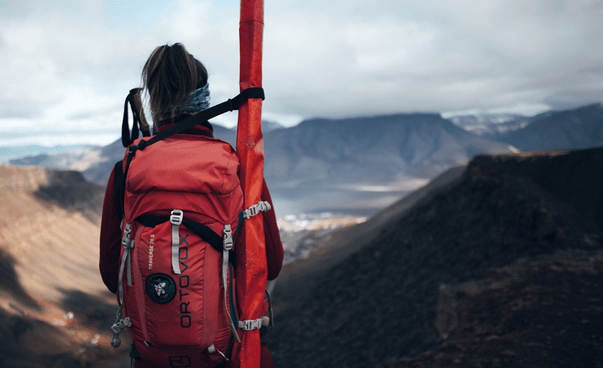
Another student, showed us a red pole that she and another course placed there earlier in July – and they placed it deep into the ice so that it would only stick out 10 cm. You can see how far it sticks out now. This is how much the glacier just melted since July!
We ended the hike at the bottom of the glacier, the terminal moraine area. There it is possible to find fossils –this is what we all started to look for!
During the hike, we paused quite a lot and looked at the different patterns of landslides, rockfalls and collapses. We also learn a lot about factors that are crucial for survival in Arctic terrains – such as clothing/layering techniques, technical breaks to adjust clothing quite often and other equipment that can define life or death, especially in situations where you have to stay outside for longer than expected (while, e.g. waiting for rescue – which can take quite long in the Arctic region). We were pretty close to Longyearbyen. For day trips, you should bring personal and group equipment that allows you to survive 12-24 hours outside. Of course, we also learn (and will learn further) about the systems and preparations in the background that ensure safety and quick emergency response.
That’s it, hope you liked this little report from the current AS-302 course and what we are up to – learning to keep YOU guys safe in the fields.
Fabienne